
This handy tool creates a KML file, which is not compressed, for use in Google Earth or Google My Maps. The number of objects in KML for My Maps is generally limited to about a 1000 points and the user is informed accordingly if this limit is reached.
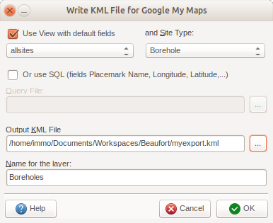
Two options allows either using a View with default fields and a specific site type to restrict the number of records or by using a SQL query. The query can have any number of fields, but needs at least a Placemark Name, a Longitude and a Latitude fields, but can have any number of fields on top of those three.
The layer name is the identifier of the layer displayed in Google Earth / My Maps.