
(Only available in South Africa)
This import function allows the direct import of WMS (Water Management System of the DWS) chemistry data into the relevant chemistry tables in Aquabase.
The import will try and match the Point and Feature Names in the import file with the Site Identifiers (SITE_ID_NR, NR_ON_MAP, ALT_NO_1,) in the Aquabase Basic Information table in the following order:
1.) “Monitoring Point Name”: SITE_ID_NR
2.) “Located on Feature Name”: SITE_ID_NR
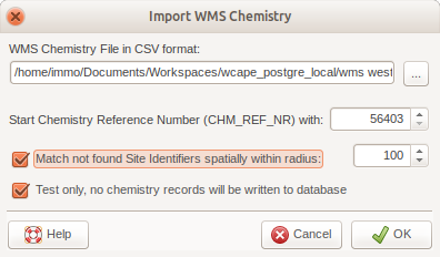
If none of the above numbers is found in the Basic Information table then the option to do a spatial match may be used to find sites within the radius specified.
Additionally the NGDB_FLAG field in the chem_000 table will contain a number specifying the nth word which was used in one of the import fields to match the sites between the two. An NGBD_FLAG of 84 means that the site was matched by spatial comparison.
The chemistry reference number defaults to the last found CHM_REF_NR in the CHEM_000 table (the samples) plus 1. But this can be changed to any number higher than the highest number in the database for easy identification onwards.
After the import there are two CSV files written into the workspace folder:
1.) WMSSitesNotFound.csv – containes all the sites that could not be found by numbers or within the radius of an existing site (spatial search)
2.) WMSResultsNotLoaded.csv – the results that could not be imported due to the sites not found and logged in the previous file.
Both of these can be used for a manual import (Import Other Table) by using the first one to create new sites and the second one to append the chemistry to the newly created sites. These can also be altered in GIS software so that the import can be repeated with these files (create a SITE_ID_NR and include it in the “Monitoring Point Name” of the remaining results file).
NOTE: You are encouraged to use the “Test only” function first to see how many records can be imported successfully (or not). Have a look at the two WMS*.csv files after the “test import”. You may want to increase the search radius in the spatial search to include a wider search for sites in the vicinity of the import sites. (Remember: the WMS import files use Cape Datum Lat/Long coordinates).